FacebookInstagramTwitterWhatsApp

Meteo Serra de' Conti tra 4 giorni. Previsioni del tempo, precipitazioni, temperatura e venti

FacebookWhatsappTwitterTelegram

Serra de' Conti
06:01
20:09
Gibbosa calante
Notte
sereno notte
Mattino
soleggiato
Pomeriggio
soleggiato
Sera
poco nuvoloso
  • 14°

    UV Normale 0

    ore

    sereno notte

    Umidità alta77%

    Raffiche normali6-14 Km/h

    Nord ovestNord O

  • 13°

    UV Normale 0

    ore

    sereno notte

    Umidità alta78%

    Raffiche normali6-13 Km/h

    Ovest nord ovestOvest NO

  • 13°

    UV Normale 0

    ore

    sereno notte

    Umidità alta79%

    Raffiche normali6-12 Km/h

    OvestOvest

  • 12°

    UV Normale 0

    ore

    sereno notte

    Umidità alta80%

    Raffiche normali5-12 Km/h

    Sud ovestSud O

  • 12°

    UV Normale 0

    ore

    sereno notte

    Umidità alta82%

    Raffiche normali6-12 Km/h

    Ovest sud ovestOvest SO

  • 11°

    UV Normale 0

    ore

    sereno notte

    Umidità alta83%

    Raffiche normali6-13 Km/h

    Ovest sud ovestOvest SO

  • 11°

    UV Normale 1

    ore

    soleggiato

    Umidità alta84%

    Raffiche normali6-13 Km/h

    OvestOvest

  • 13°

    UV Normale 2

    ore

    soleggiato

    Umidità alta77%

    Raffiche normali6-13 Km/h

    OvestOvest

  • 14°

    UV Normale 3

    ore

    soleggiato

    Umidità alta71%

    Raffiche normali7-14 Km/h

    OvestOvest

  • 16°

    UV Normale 4

    ore

    soleggiato

    Umidità normale64%

    Raffiche normali7-14 Km/h

    Ovest nord ovestOvest NO

  • 17°

    UV Elevato 6

    ore

    soleggiato

    Umidità normale62%

    Raffiche normali8-15 Km/h

    Nord ovestNord O

  • 18°

    UV Elevato 7

    ore

    soleggiato

    Umidità normale60%

    Raffiche normali9-16 Km/h

    Nord ovestNord O

  • 19°

    UV Elevato 8

    ore

    soleggiato

    Umidità normale58%

    Raffiche normali10-17 Km/h

    Nord nord ovestNord NO

  • 20°

    UV Elevato 9

    ore

    soleggiato

    Umidità normale56%

    Raffiche normali11-18 Km/h

    NordNord

  • 21°

    UV Elevato 8

    ore

    soleggiato

    Umidità normale54%

    Raffiche forti12-19 Km/h

    Nord nord est intensoNord NE

  • 22°

    UV Elevato 7

    ore

    soleggiato

    Umidità normale52%

    Raffiche forti13-20 Km/h

    Nord est intensoNord E

  • 23°

    UV Elevato 6

    ore

    soleggiato

    Umidità normale50%

    Raffiche forti12-19 Km/h

    Nord est intensoNord E

  • 22°

    UV Normale 4

    ore

    soleggiato

    Umidità normale55%

    Raffiche forti12-19 Km/h

    Nord est intensoNord E

  • 21°

    UV Normale 3

    ore

    soleggiato

    Umidità normale60%

    Raffiche normali11-18 Km/h

    Est nord estEst NE

  • 19°

    UV Normale 2

    ore

    soleggiato

    Umidità normale64%

    Raffiche normali10-18 Km/h

    Est nord estEst NE

  • 18°

    UV Normale 1

    ore

    prevalentemente soleggiato

    Umidità normale69%

    Raffiche normali9-17 Km/h

    Est nord estEst NE

  • 17°

    UV Normale 0

    ore

    poco nuvoloso

    Umidità alta74%

    Raffiche normali8-17 Km/h

    EstEst

  • 17°

    UV Normale 0

    ore

    poco nuvoloso

    Umidità alta76%

    Raffiche normali8-15 Km/h

    Est nord estEst NE

  • 16°

    UV Normale 0

    ore

    poco nuvoloso

    Umidità alta78%

    Raffiche normali7-14 Km/h

    Nord estNord E

  • 15°

    UV Normale 0

    ore

    poco nuvoloso

    Umidità alta79%

    Raffiche normali6-13 Km/h

    Nord nord estNord NE

Meteo provincia di Ancona
Meteo Centro Italia
Oggi

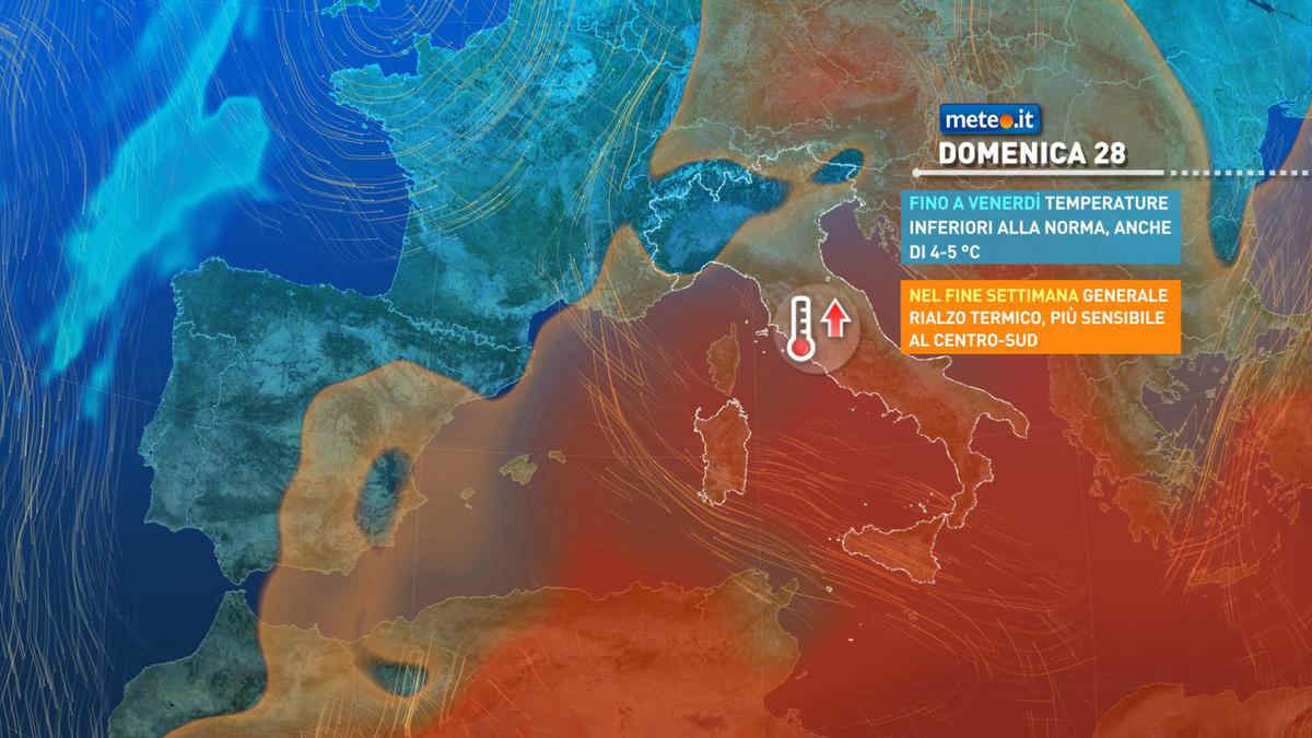
Al mattino cielo in prevalenza nuvoloso su tutte le regioni. Temperature minime in aumento. Nel pomeriggio cielo generalmente nuvoloso. Possibilita' di brevi piogge o locali rovesci nelle zone interne, sul nord delle Marche e sul basso Lazio. Temperature massime in lieve rialzo. Venti per lo piu' deboli, salvo rinforzi da sudest sul mar Tirreno centrale. Mari: mosso il medio Tirreno, poco mossi gli altri.

Notizie
TendenzaMeteo, dal 28 aprile picchi oltre 25 gradi: ecco dove
Meteo, dal 28 aprile picchi oltre 25 gradi: ecco dove
Temperature in netto aumento: si torna sopra le medie soprattutto al Centro-sud e sulle Isole dove potremo superare i 25 gradi. La tendenza meteo
Mediaset

Ultimo aggiornamento Venerdì 26 Aprile ore 06:22

Copyright © 1999-2020 RTI S.p.A. Direzione Business Digital - P.Iva 03976881007 - Tutti i diritti riservati - Per la pubblicità Mediamond S.p.a. RTI spa, Gruppo Mediaset - Sede legale: 00187 Roma Largo del Nazareno 8 - Cap. Soc. € 500.000.007,00 int. vers. - Registro delle Imprese di Roma, C.F.06921720154