FacebookInstagramTwitterWhatsApp

Meteo San Giovanni in Croce tra 7 giorni. Previsioni del tempo, precipitazioni, temperatura e venti

FacebookWhatsappTwitterTelegram

San Giovanni in Croce
05:53
20:37
Luna crescente
Notte
cielo in gran parte nuvoloso
Mattino
cielo in gran parte nuvoloso
Pomeriggio
prevalentemente soleggiato
Sera
sereno notte
  • 15°

    UV Normale 0

    ore

    poco nuvoloso

    Umidità alta72%

    Raffiche forti11-26 Km/h

    Est sud est intensoEst SE

  • 15°

    UV Normale 0

    ore

    poco nuvoloso

    Umidità alta76%

    Raffiche forti11-26 Km/h

    Est intensoEst

  • 14°

    UV Normale 0

    ore

    cielo in gran parte nuvoloso

    Umidità alta79%

    Raffiche forti11-26 Km/h

    Est intensoEst

  • 13°

    UV Normale 0

    ore

    cielo in gran parte nuvoloso

    Umidità alta83%

    Raffiche forti11-26 Km/h

    Est intensoEst

  • 12°

    UV Normale 0

    ore

    cielo in gran parte nuvoloso

    Umidità alta87%

    Raffiche forti10-26 Km/h

    Est intensoEst

  • 11°

    UV Normale 1

    ore

    cielo in gran parte nuvoloso

    Umidità alta91%

    Raffiche forti10-25 Km/h

    Est intensoEst

  • 12°

    UV Normale 2

    ore

    cielo in gran parte nuvoloso

    Umidità alta88%

    Raffiche forti10-25 Km/h

    Est intensoEst

  • 13°

    UV Normale 3

    ore

    cielo in gran parte nuvoloso

    Umidità alta85%

    Raffiche forti10-25 Km/h

    Est intensoEst

  • 14°

    UV Normale 4

    ore

    cielo in gran parte nuvoloso

    Umidità alta81%

    Raffiche forti10-25 Km/h

    Est intensoEst

  • 15°

    UV Normale 5

    ore

    cielo in gran parte nuvoloso

    Umidità alta78%

    Raffiche forti10-24 Km/h

    Est intensoEst

  • 16°

    UV Elevato 6

    ore

    cielo in gran parte nuvoloso

    Umidità alta73%

    Raffiche forti9-22 Km/h

    Est sud est intensoEst SE

  • 17°

    UV Elevato 7

    ore

    cielo in gran parte nuvoloso

    Umidità normale68%

    Raffiche forti8-19 Km/h

    Est sud est intensoEst SE

  • 18°

    UV Elevato 8

    ore

    cielo in gran parte nuvoloso

    Umidità normale63%

    Raffiche normali8-16 Km/h

    Est sud estEst SE

  • 19°

    UV Elevato 9

    ore

    cielo in gran parte nuvoloso

    Umidità normale58%

    Raffiche normali7-13 Km/h

    Est sud estEst SE

  • 20°

    UV Elevato 8

    ore

    prevalentemente soleggiato

    Umidità normale53%

    Raffiche normali6-11 Km/h

    Est sud estEst SE

  • 21°

    UV Elevato 7

    ore

    prevalentemente soleggiato

    Umidità normale48%

    Raffiche normali5-8 Km/h

    Sud estSud E

  • 22°

    UV Elevato 6

    ore

    prevalentemente soleggiato

    Umidità normale43%

    Raffiche normali5-11 Km/h

    Sud estSud E

  • 21°

    UV Normale 4

    ore

    prevalentemente soleggiato

    Umidità normale46%

    Raffiche normali5-13 Km/h

    Est sud estEst SE

  • 21°

    UV Normale 3

    ore

    prevalentemente soleggiato

    Umidità normale48%

    Raffiche normali5-15 Km/h

    Est sud estEst SE

  • 20°

    UV Normale 2

    ore

    prevalentemente soleggiato

    Umidità normale51%

    Raffiche normali5-18 Km/h

    Est sud estEst SE

  • 20°

    UV Normale 1

    ore

    soleggiato

    Umidità normale53%

    Raffiche forti6-20 Km/h

    Est sud est intensoEst SE

  • 19°

    UV Normale 0

    ore

    sereno notte

    Umidità normale56%

    Raffiche forti6-23 Km/h

    Est intensoEst

  • 18°

    UV Normale 0

    ore

    sereno notte

    Umidità normale61%

    Raffiche forti6-23 Km/h

    Est intensoEst

  • 18°

    UV Normale 0

    ore

    sereno notte

    Umidità normale66%

    Raffiche forti6-23 Km/h

    Est intensoEst

  • 16°

    UV Normale 0

    ore

    sereno notte

    Umidità normale70%

    Raffiche forti6-23 Km/h

    Est intensoEst

Meteo provincia di Cremona
Meteo Nord-Ovest Italia
Oggi

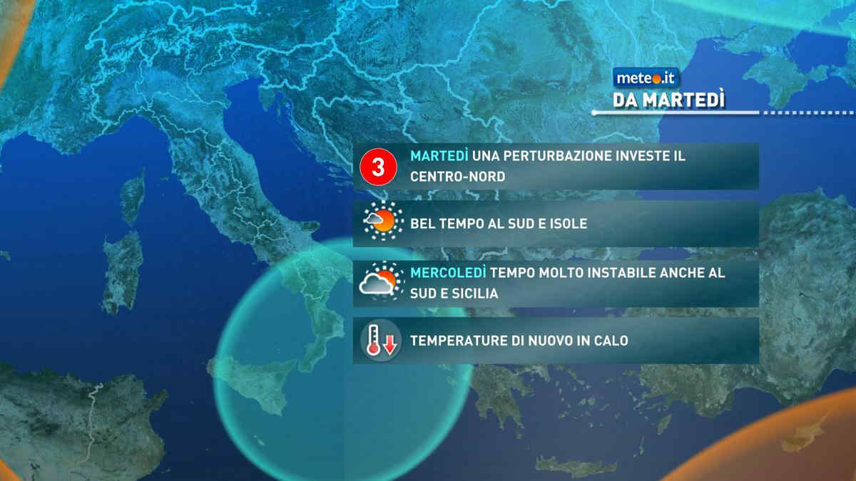
Al mattino cielo parzialmente nuvoloso in tutte le regioni. Temperature minime stazionarie o in lieve aumento. Nel pomeriggio nubi sparse con un cielo da parzialmente nuvoloso a nuvoloso ma con basso rischio di piogge. Temperature massime in lieve aumento con valori intorno ai 20 gradi. Venti deboli, di Libeccio nel Mar Ligure che resta un po' mosso nel settore orientale e meridionale.

Notizie
TendenzaMeteo, vortice di bassa pressione porta nuovo maltempo da martedì 7
Meteo, vortice di bassa pressione porta nuovo maltempo da martedì 7
L'alta pressione si allontanerà, spinta verso est da un vortice che in settimana porterà piogge e temporali: la tendenza
Mediaset

Ultimo aggiornamento Sabato 04 Maggio ore 13:43

Copyright © 1999-2020 RTI S.p.A. Direzione Business Digital - P.Iva 03976881007 - Tutti i diritti riservati - Per la pubblicità Mediamond S.p.a. RTI spa, Gruppo Mediaset - Sede legale: 00187 Roma Largo del Nazareno 8 - Cap. Soc. € 500.000.007,00 int. vers. - Registro delle Imprese di Roma, C.F.06921720154