FacebookInstagramTwitterWhatsApp

Meteo San Damiano d'Asti tra 4 giorni. Previsioni del tempo, precipitazioni, temperatura e venti

FacebookWhatsappTwitterTelegram

San Damiano d'Asti
06:27
20:24
Luna piena
Notte
poco nuvoloso
Mattino
soleggiato
Pomeriggio
soleggiato
Sera
sereno notte
  • UV Normale 0

    ore

    cielo in gran parte nuvoloso

    Umidità normale66%

    Raffiche normali10-18 Km/h

    Nord nord ovestNord NO

  • UV Normale 0

    ore

    cielo in gran parte nuvoloso

    Umidità normale67%

    Raffiche normali9-18 Km/h

    Nord ovestNord O

  • UV Normale 0

    ore

    poco nuvoloso

    Umidità normale69%

    Raffiche normali9-17 Km/h

    Ovest nord ovestOvest NO

  • UV Normale 0

    ore

    poco nuvoloso

    Umidità normale70%

    Raffiche normali9-17 Km/h

    OvestOvest

  • UV Normale 0

    ore

    poco nuvoloso

    Umidità alta71%

    Raffiche normali8-16 Km/h

    OvestOvest

  • UV Normale 0

    ore

    poco nuvoloso

    Umidità alta73%

    Raffiche normali8-16 Km/h

    OvestOvest

  • UV Normale 1

    ore

    prevalentemente soleggiato

    Umidità alta74%

    Raffiche normali8-16 Km/h

    Ovest sud ovestOvest SO

  • UV Normale 2

    ore

    prevalentemente soleggiato

    Umidità normale69%

    Raffiche normali8-16 Km/h

    Ovest sud ovestOvest SO

  • UV Normale 3

    ore

    soleggiato

    Umidità normale63%

    Raffiche normali8-16 Km/h

    Ovest sud ovestOvest SO

  • UV Normale 4

    ore

    soleggiato

    Umidità normale58%

    Raffiche normali8-16 Km/h

    Ovest sud ovestOvest SO

  • UV Elevato 6

    ore

    soleggiato

    Umidità normale54%

    Raffiche normali8-15 Km/h

    Sud ovestSud O

  • 10°

    UV Elevato 7

    ore

    soleggiato

    Umidità normale49%

    Raffiche normali8-14 Km/h

    Sud ovestSud O

  • 11°

    UV Elevato 8

    ore

    soleggiato

    Umidità normale45%

    Raffiche normali8-14 Km/h

    SudSud

  • 13°

    UV Elevato 9

    ore

    soleggiato

    Umidità normale41%

    Raffiche normali8-13 Km/h

    Sud sud estSud SE

  • 14°

    UV Elevato 8

    ore

    soleggiato

    Umidità normale37%

    Raffiche normali8-13 Km/h

    Sud estSud E

  • 15°

    UV Elevato 7

    ore

    soleggiato

    Umidità normale32%

    Raffiche normali8-12 Km/h

    Est sud estEst SE

  • 16°

    UV Elevato 6

    ore

    soleggiato

    Umidità normale28%

    Raffiche normali8-12 Km/h

    Est sud estEst SE

  • 15°

    UV Normale 4

    ore

    soleggiato

    Umidità normale33%

    Raffiche normali8-13 Km/h

    Est sud estEst SE

  • 14°

    UV Normale 3

    ore

    soleggiato

    Umidità normale38%

    Raffiche normali8-13 Km/h

    Est sud estEst SE

  • 14°

    UV Normale 2

    ore

    soleggiato

    Umidità normale43%

    Raffiche normali8-13 Km/h

    Est sud estEst SE

  • 13°

    UV Normale 1

    ore

    soleggiato

    Umidità normale48%

    Raffiche normali8-13 Km/h

    Est sud estEst SE

  • 12°

    UV Normale 0

    ore

    sereno notte

    Umidità normale53%

    Raffiche normali8-13 Km/h

    Est sud estEst SE

  • 11°

    UV Normale 0

    ore

    sereno notte

    Umidità normale56%

    Raffiche normali8-13 Km/h

    Est sud estEst SE

  • 11°

    UV Normale 0

    ore

    sereno notte

    Umidità normale58%

    Raffiche normali7-13 Km/h

    EstEst

  • 10°

    UV Normale 0

    ore

    sereno notte

    Umidità normale60%

    Raffiche normali7-13 Km/h

    Est nord estEst NE

Meteo provincia di Asti
Meteo Nord-Ovest Italia
Oggi

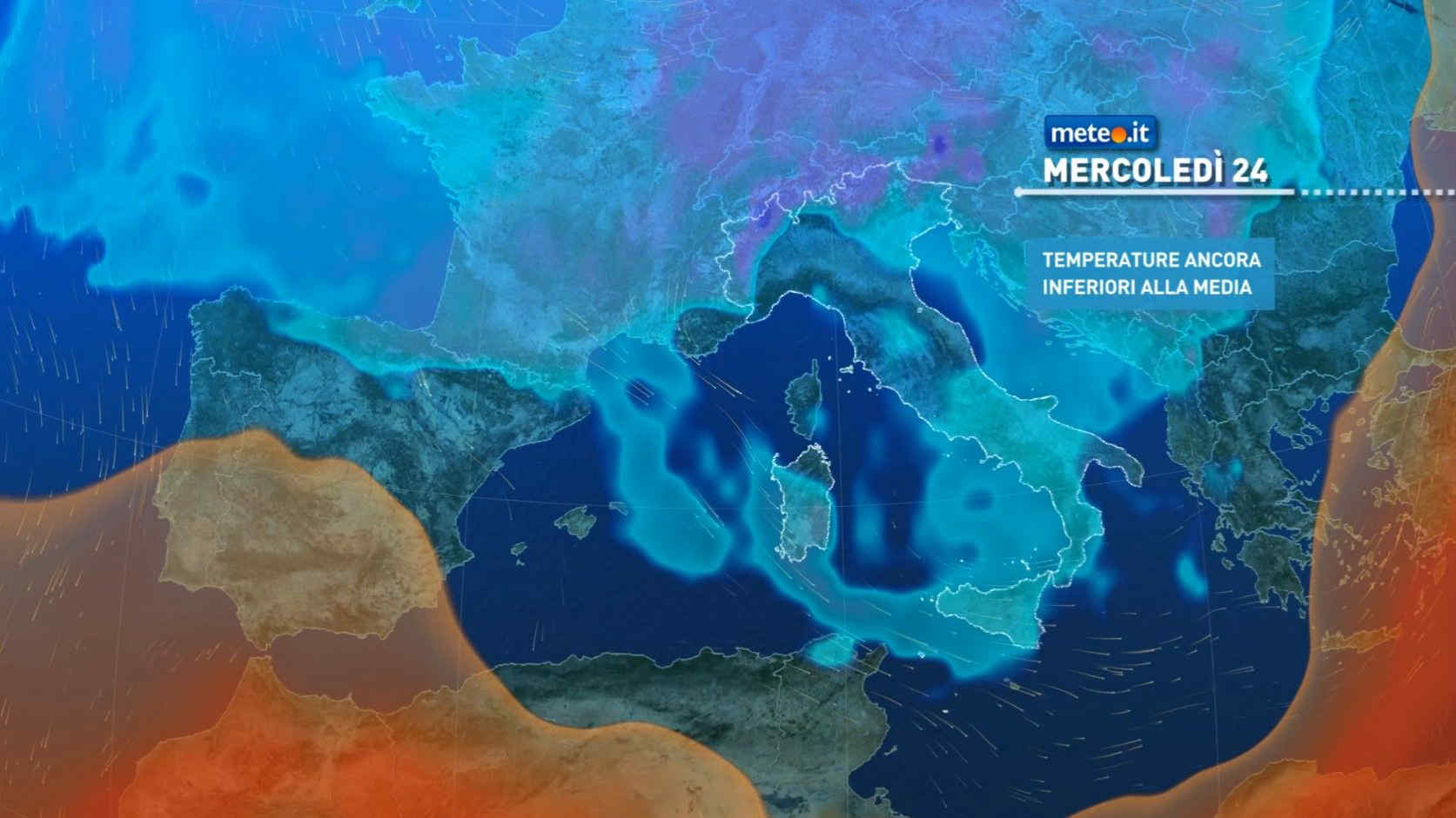
Al mattino cielo sereno o poco nuvoloso, salvo una residua nuvolosita' a ridosso della Valle d'Aosta e delle Alpi occidentali, con gli ultimi fiocchi di neve prima dell'alba fin verso 1200 metri circa. Temperature minime in lieve rialzo. Nel pomeriggio maggiore variabilita', con un cielo tra il poco nuvoloso e l'irregolarmente nuvoloso un po' su tutti i settori. Spazi soleggiati piu' ampi verso ovest, addensamenti piu' consistenti ad est, con possibili brevi piogge o locali rovesci nel sudest della Lombardia. Temperature massime senza grandi variazioni. Venti settentrionali in rinforzo, da moderati a localmente forti fino alle basse quote. Mar Ligure mosso.

Notizie
TendenzaMeteo, aria artica e nucleo instabile in arrivo ad inizio settimana: la tendenza fino al Ponte del 25 aprile
Meteo, aria artica e nucleo instabile in arrivo ad inizio settimana: la tendenza fino al Ponte del 25 aprile
Settimana prossima continuerà ad essere fredda, e il passaggio di alcuni impulsi perturbati porterà nuove fasi instabili: la tendenza meteo
Mediaset

Ultimo aggiornamento Sabato 20 Aprile ore 15:55

Copyright © 1999-2020 RTI S.p.A. Direzione Business Digital - P.Iva 03976881007 - Tutti i diritti riservati - Per la pubblicità Mediamond S.p.a. RTI spa, Gruppo Mediaset - Sede legale: 00187 Roma Largo del Nazareno 8 - Cap. Soc. € 500.000.007,00 int. vers. - Registro delle Imprese di Roma, C.F.06921720154