FacebookInstagramTwitterWhatsApp

Meteo Piasco domani. Previsioni del tempo, precipitazioni, temperatura e venti

FacebookWhatsappTwitterTelegram

Piasco
06:38
20:20
Gibbosa crescente
Notte
sereno notte
Mattino
soleggiato
Pomeriggio
soleggiato
Sera
sereno notte
  • UV Normale 0

    ore

    poco nuvoloso

    Umidità normale56%

    Raffiche forti11-22 Km/h

    Ovest sud ovest intensoOvest SO

  • UV Normale 0

    ore

    poco nuvoloso

    Umidità normale55%

    Raffiche forti11-21 Km/h

    Ovest sud ovest intensoOvest SO

  • UV Normale 0

    ore

    sereno notte

    Umidità normale54%

    Raffiche forti11-20 Km/h

    Ovest sud ovest intensoOvest SO

  • UV Normale 0

    ore

    sereno notte

    Umidità normale53%

    Raffiche forti11-19 Km/h

    Ovest sud ovest intensoOvest SO

  • UV Normale 0

    ore

    sereno notte

    Umidità normale52%

    Raffiche forti11-19 Km/h

    Ovest sud ovest intensoOvest SO

  • UV Normale 0

    ore

    sereno notte

    Umidità normale51%

    Raffiche forti10-19 Km/h

    Ovest sud ovest intensoOvest SO

  • UV Normale 1

    ore

    soleggiato

    Umidità normale50%

    Raffiche forti10-20 Km/h

    Ovest sud ovest intensoOvest SO

  • UV Normale 2

    ore

    soleggiato

    Umidità normale44%

    Raffiche forti9-20 Km/h

    Ovest sud ovest intensoOvest SO

  • UV Normale 3

    ore

    soleggiato

    Umidità normale38%

    Raffiche forti9-20 Km/h

    Ovest sud ovest intensoOvest SO

  • UV Normale 4

    ore

    soleggiato

    Umidità normale32%

    Raffiche forti9-20 Km/h

    Ovest sud ovest intensoOvest SO

  • UV Elevato 6

    ore

    soleggiato

    Umidità normale30%

    Raffiche forti9-19 Km/h

    Ovest sud ovest intensoOvest SO

  • 10°

    UV Elevato 7

    ore

    soleggiato

    Umidità normale29%

    Raffiche normali9-18 Km/h

    Sud ovestSud O

  • 11°

    UV Elevato 8

    ore

    soleggiato

    Umidità normale27%

    Raffiche normali9-17 Km/h

    SudSud

  • 13°

    UV Elevato 9

    ore

    soleggiato

    Umidità normale25%

    Raffiche normali9-16 Km/h

    Sud sud estSud SE

  • 14°

    UV Elevato 8

    ore

    soleggiato

    Umidità normale23%

    Raffiche normali9-15 Km/h

    Sud estSud E

  • 15°

    UV Elevato 7

    ore

    soleggiato

    Umidità normale22%

    Raffiche normali9-13 Km/h

    Est sud estEst SE

  • 16°

    UV Elevato 6

    ore

    soleggiato

    Umidità normale20%

    Raffiche normali8-13 Km/h

    EstEst

  • 15°

    UV Normale 4

    ore

    soleggiato

    Umidità normale23%

    Raffiche normali8-13 Km/h

    EstEst

  • 14°

    UV Normale 3

    ore

    soleggiato

    Umidità normale26%

    Raffiche normali7-13 Km/h

    Est nord estEst NE

  • 14°

    UV Normale 2

    ore

    soleggiato

    Umidità normale29%

    Raffiche normali6-13 Km/h

    Est nord estEst NE

  • 13°

    UV Normale 1

    ore

    soleggiato

    Umidità normale32%

    Raffiche normali5-13 Km/h

    Nord estNord E

  • 12°

    UV Normale 0

    ore

    sereno notte

    Umidità normale35%

    Raffiche normali5-13 Km/h

    Nord nord estNord NE

  • 12°

    UV Normale 0

    ore

    sereno notte

    Umidità normale36%

    Raffiche normali5-14 Km/h

    Nord estNord E

  • 11°

    UV Normale 0

    ore

    sereno notte

    Umidità normale37%

    Raffiche normali6-16 Km/h

    Est nord estEst NE

  • 10°

    UV Normale 0

    ore

    sereno notte

    Umidità normale37%

    Raffiche normali7-17 Km/h

    Est sud estEst SE

Qualità dell'aria Piasco
AccettabileAccettabile
Qualità aria in peggioramentoIn peggioramento
ApriDati medi giornata

O3(Ozono)

85.9

NO2(Diossido di azoto)

2.3

SO2(Anidride solforosa)

0.2

PM10(Materia particolata)

5.4

PM25(Materia particolata)

4.2

Meteo provincia di Cuneo
Meteo Nord-Ovest Italia
Oggi

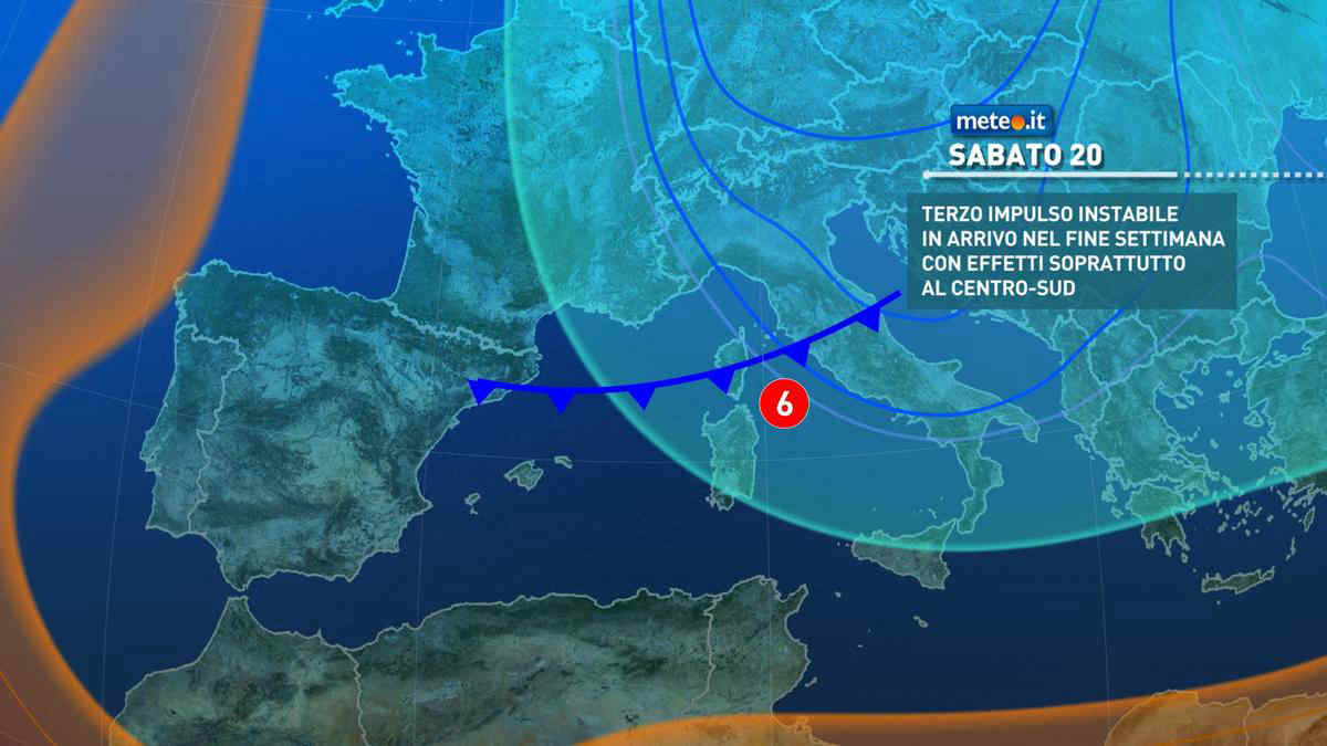
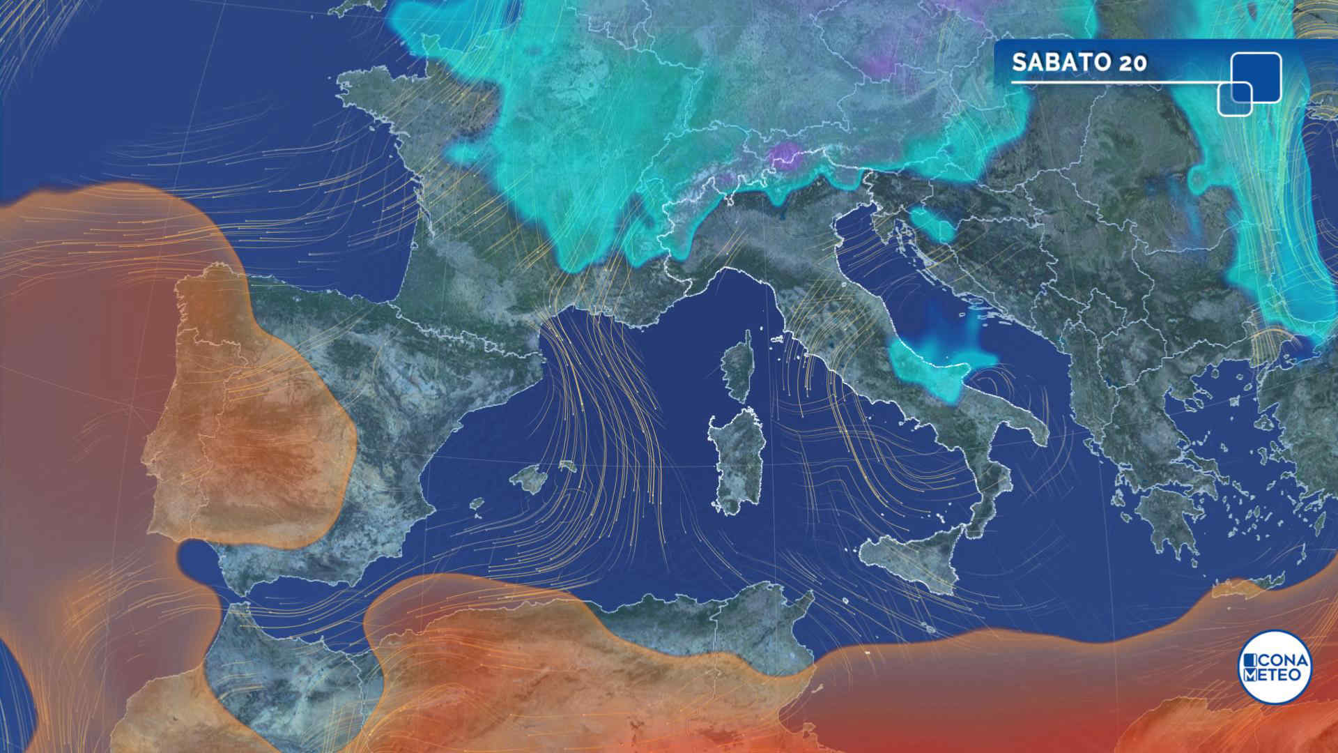
Al mattino nuvolosita' variabile in aumento. Deboli nevicate isolate sulle Alpi valdostane. Temperature minime stabili o in leggero calo. Nel pomeriggio cielo irregolarmente nuvoloso, con tendenza a schiarite da nord verso sud. Possibili rovesci isolati su basso Piemonte, Liguria, Lombardia centro orientale. Temperature massime in diminuzione. Venti: moderati di tramontana in Liguria, a carattere di foehn nelle valli alpine. Mar Ligure mosso al largo.

Notizie
TendenzaMeteo, da sabato 20 aprile nuovo impulso instabile: gli effetti
Meteo, da sabato 20 aprile nuovo impulso instabile: gli effetti
Piogge, venti forti e neve: si profila una fase meteo molto movimentata con clima da tardo inverno sull'Italia. La tendenza meteo dal 20 aprile
Mediaset

Ultimo aggiornamento Giovedì 18 Aprile ore 09:45

Copyright © 1999-2020 RTI S.p.A. Direzione Business Digital - P.Iva 03976881007 - Tutti i diritti riservati - Per la pubblicità Mediamond S.p.a. RTI spa, Gruppo Mediaset - Sede legale: 00187 Roma Largo del Nazareno 8 - Cap. Soc. € 500.000.007,00 int. vers. - Registro delle Imprese di Roma, C.F.06921720154