FacebookInstagramTwitterWhatsApp

Meteo Mariano del Friuli tra 6 giorni. Previsioni del tempo, precipitazioni, temperatura e venti

FacebookWhatsappTwitterTelegram

Mariano del Friuli
05:54
20:13
Gibbosa calante
Notte
poco nuvoloso
Mattino
prevalentemente soleggiato
Pomeriggio
soleggiato
Sera
sereno notte
  • 15°

    UV Normale 0

    ore

    sereno notte

    Umidità normale61%

    Raffiche normali5-10 Km/h

    Est nord estEst NE

  • 14°

    UV Normale 0

    ore

    sereno notte

    Umidità normale63%

    Raffiche normali4-9 Km/h

    Est nord estEst NE

  • 13°

    UV Normale 0

    ore

    poco nuvoloso

    Umidità normale65%

    Raffiche normali4-9 Km/h

    Est nord estEst NE

  • 13°

    UV Normale 0

    ore

    poco nuvoloso

    Umidità normale67%

    Raffiche normali4-8 Km/h

    Est nord estEst NE

  • 12°

    UV Normale 0

    ore

    poco nuvoloso

    Umidità normale68%

    Raffiche normali4-8 Km/h

    Est nord estEst NE

  • 11°

    UV Normale 1

    ore

    prevalentemente soleggiato

    Umidità normale70%

    Raffiche normali3-8 Km/h

    Est nord estEst NE

  • 13°

    UV Normale 2

    ore

    prevalentemente soleggiato

    Umidità normale67%

    Raffiche normali3-8 Km/h

    Est nord estEst NE

  • 14°

    UV Normale 3

    ore

    prevalentemente soleggiato

    Umidità normale64%

    Raffiche normali3-8 Km/h

    Est nord estEst NE

  • 16°

    UV Normale 4

    ore

    prevalentemente soleggiato

    Umidità normale61%

    Raffiche normali3-8 Km/h

    EstEst

  • 17°

    UV Normale 5

    ore

    prevalentemente soleggiato

    Umidità normale58%

    Raffiche normali3-8 Km/h

    EstEst

  • 18°

    UV Elevato 6

    ore

    prevalentemente soleggiato

    Umidità normale55%

    Raffiche normali4-9 Km/h

    EstEst

  • 20°

    UV Elevato 7

    ore

    prevalentemente soleggiato

    Umidità normale51%

    Raffiche normali5-10 Km/h

    EstEst

  • 21°

    UV Elevato 8

    ore

    prevalentemente soleggiato

    Umidità normale48%

    Raffiche normali5-11 Km/h

    EstEst

  • 22°

    UV Elevato 9

    ore

    prevalentemente soleggiato

    Umidità normale44%

    Raffiche normali6-12 Km/h

    EstEst

  • 24°

    UV Elevato 8

    ore

    soleggiato

    Umidità normale41%

    Raffiche normali7-13 Km/h

    EstEst

  • 25°

    UV Elevato 7

    ore

    soleggiato

    Umidità normale37%

    Raffiche normali8-14 Km/h

    EstEst

  • 24°

    UV Elevato 6

    ore

    soleggiato

    Umidità normale41%

    Raffiche normali8-15 Km/h

    EstEst

  • 22°

    UV Normale 4

    ore

    soleggiato

    Umidità normale44%

    Raffiche normali9-16 Km/h

    EstEst

  • 21°

    UV Normale 3

    ore

    soleggiato

    Umidità normale48%

    Raffiche normali10-18 Km/h

    Est nord estEst NE

  • 20°

    UV Normale 2

    ore

    soleggiato

    Umidità normale52%

    Raffiche forti11-19 Km/h

    Est nord est intensoEst NE

  • 18°

    UV Normale 1

    ore

    soleggiato

    Umidità normale55%

    Raffiche forti12-20 Km/h

    Est nord est intensoEst NE

  • 17°

    UV Normale 0

    ore

    sereno notte

    Umidità normale59%

    Raffiche forti13-21 Km/h

    Nord est intensoNord E

  • 17°

    UV Normale 0

    ore

    sereno notte

    Umidità normale62%

    Raffiche forti12-20 Km/h

    Nord est intensoNord E

  • 16°

    UV Normale 0

    ore

    sereno notte

    Umidità normale65%

    Raffiche forti11-19 Km/h

    Nord est intensoNord E

  • 15°

    UV Normale 0

    ore

    sereno notte

    Umidità normale68%

    Raffiche forti10-19 Km/h

    Nord est intensoNord E

Meteo provincia di Gorizia
Meteo Nord-Est Italia
Oggi

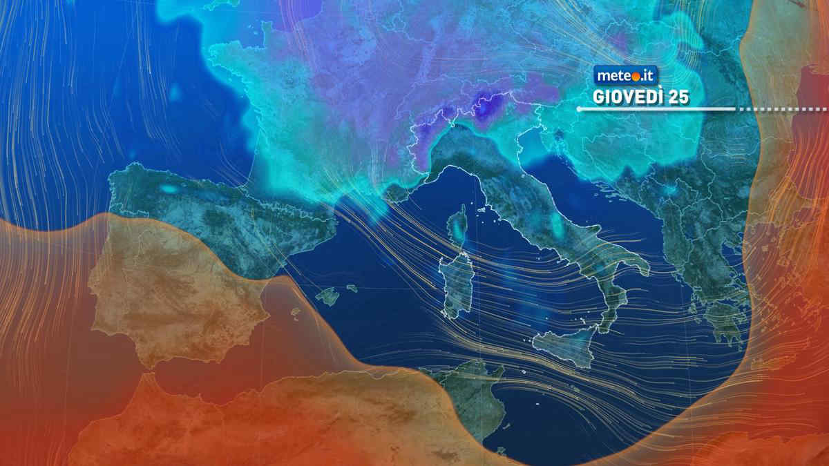
Al mattino molte nuvole con qualche parziale apertura solo sull'Emilia piu' occidentale e in Trentino Alto Adige. Molte nuvole e locali precipitazioni nelle altre zone; possibili rovesci nel Polesine e limite della neve oltre i 1000 metri circa. Temperature minime senza grandi variazioni. Nel pomeriggio ancora irregolarmente nuvoloso con locali fenomeni anche a carattere di breve rovescio tra Veneto, Trentino e Friuli Venezia Giulia; neve oltre 1100-1200 metri di quota. Temperature massime per lo piu' in leggero rialzo. Venti in prevalenza deboli. Mare adriatico da poco mosso a localmente mosso.

Notizie
TendenzaMeteo: stop al freddo nel weekend, ma arriva ancora qualche pioggia. La tendenza da sabato 27 aprile
Meteo: stop al freddo nel weekend, ma arriva ancora qualche pioggia. La tendenza da sabato 27 aprile
Gli aggiornamenti meteo confermano che già dal 25 aprile si attenua l'afflusso di aria fredda, con temperature anche oltre la norma nel weekend
Mediaset

Ultimo aggiornamento Mercoledì 24 Aprile ore 16:16

Copyright © 1999-2020 RTI S.p.A. Direzione Business Digital - P.Iva 03976881007 - Tutti i diritti riservati - Per la pubblicità Mediamond S.p.a. RTI spa, Gruppo Mediaset - Sede legale: 00187 Roma Largo del Nazareno 8 - Cap. Soc. € 500.000.007,00 int. vers. - Registro delle Imprese di Roma, C.F.06921720154